
Although every sign in the area claims it to be "Bond Lake" everyone in this area refers to it as "Bond's Lake", doesn't really matter; it's a sweet spot.
For years I only knew Bond's Lake to be a sledding hill on the north of the road and a lake that comes right up to the edge of the road on the south with a few picnic tables and shelters scattered along its shores. Never really thought of it as a place to take a hike,until we went beyond the obvious lake in the front of the park. That's where the real treasures are!
This time in, we passed the main entrance and continued up to Blacknose Spring Road which brings you into the Tuscarora Indian Nation lands. There's a place to park to accomodate a fair number of cars and today there were quite a few trucks in the lot. To be expected, I guess; it was a great day.

The path is very wide - large enough for a vehicle to drive on although the entrances are all blocked with either downed trees or chain, etc. so that's not going to be a problem. In short order, we came across one of the 'back' lakes. I'm not sure exactly how many bodies of water are in this park, but I think there are at least 5 or so.


The main path will lead you right past the lake and it goes to the back of the park which opens up into a huge field.

We tried a branch off the trail in a direction away from the lake which we hadn't tried before, but in short order the trail just became a mud pit, so we turned back around and cut over to follow the trail through the woods that leads to the lake edge.
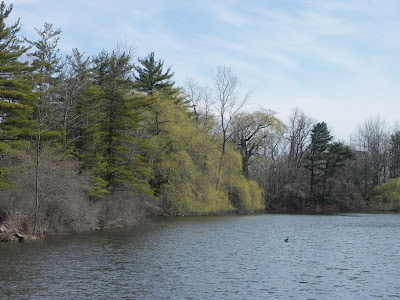
The trail is not marked in any way, just an obvious walkway that hikers have worn down. It meanders out onto a somewhat steep, narrow peninsula and the views are just beautiful on either side. A few Canada Geese kept us company along the way.
 Portions of the path are steep and narrow; I would not recommend bringing small children.

 Once on top of the peninsula, the views from both left and right are equally pretty. On the left is the large lake and to the right a small cove.

Toward the end, a nice open flat spot appears which offers a great view of the lake. A leftover campfire circle proves I'm not the only one who thinks this is a nice spot to take in the view.
 This is the view from the tip of the peninsula looking east, away from the large lake. So tranquil compared to the 'lake side'.

The trail is not marked in any way, just an obvious walkway that hikers have worn down. It meanders out onto a somewhat steep, narrow peninsula and the views are just beautiful on either side. A few Canada Geese kept us company along the way.
Portions of the path are steep and narrow; I would not recommend bringing small children.Once on top of the peninsula, the views from both left and right are equally pretty. On the left is the large lake and to the right a small cove.Toward the end, a nice open flat spot appears which offers a great view of the lake. A leftover campfire circle proves I'm not the only one who thinks this is a nice spot to take in the view.
This is the view from the tip of the peninsula looking east, away from the large lake. So tranquil compared to the 'lake side'.
Love the way this huge slab is balanced on the small boulder along the far shore.

After leaving this area, we cut through the woods further and came out on the other side to a large wide path/roadway. This path cuts between the cove area you can see from the peninsula on the large lake and another smaller lake filled with coves and islands that just beg to be explored. I don't know if canoeing is allowed; I've never seen anyone in the water.

Here's the view from the same spot looking west.
The pine trees are on the peninsula I was just on a few minutes before.

A view to the east into one of the many cove areas tucked in along the shoreline.
 The Canada Geese obviously preferred this lake as opposed to the larger lake. Probably because it was much smaller and not as 'exposed' as the other lake. They certainly were vocal - watch the video to hear them chattering on and on.
Although the scenery in the park is a sight to behold, I will admit there are a few drawbacks. First and foremost - litter - I have never seen so much garbage; from beer bottles, coffee cups, cans, food wrappers, etc. all over the trails. Horrible. The worst I have ever seen. The other issue is the Niagara Sportsmen's Club has their shooting range either in the park, or right next to it. For the majority of the hike gunshots were a constant interruption. Maybe during the week it would be a quieter hike.

GREAT PLACE TO EXPLORE...............
ReplyDeleteI know, this was the area of my childhood home. Just a magical spot if you love nature!
ReplyDelete